DOI Nr.: https://doi.org/10.25929/zpn3-3v70
Roland Zink
Technische Hochschule Deggendorf
Martin Steininger
Technische Hochschule Deggendorf
ABSTRACT
The effective participation of citizens is regarded as an essential aspect when social friction in spatial and regional planning is to be avoided. However, in which form participation should be enabled is often controversial and is currently undergoing a significant change as communication and spatial planning become increasingly digitized. Motivated by this social and economic relevance, this paper presents the development of the digital application PUBinPLAN which aims at rendering spatial planning processes more transparent and interactive. In order to meet this challenge, the approach combines the methods of Public Participation GIS, Crowdsourcing and Augmented Reality. As a browser solution (HTML5, CSS, JavaScript, CakePHP), an application is created for both desktop and mobile use. In addition to the conceptual description of PUBinPLAN, this publication focuses on the Augmented Reality application which is developed as a hybrid app. In combination with Wikitude SDK the cross-platform Cordova is used as a development framework. First results show a 3D park bench from Trimble SketchUP 3D Warehouse visualized via Mobile Monitor Augmented Reality.
Eine wirksame Bürgerbeteiligung gilt heute als wesentlicher Baustein, um gesellschaftliche Friktionen bei der Raum- und Regionalplanung zu vermeiden. Die Form der Partizipation ist jedoch oftmals umstritten und unterliegt aufgrund der Digitalisierung von sowohl Kommunikationsweisen als auch von Raumplanungsprozessen aktuell einem starken Wandel. Motiviert durch die hohe gesellschaftliche und wirtschaftliche Relevanz von Beteiligung beschreibt der Beitrag die Entwicklung der digitalen Anwendung PUBinPLAN, mit der sich räumliche Planungsprozesse transparenter und interaktiver gestalten lassen. Um diesem Anspruch gerecht zu werden, kombiniert PUBinPLAN Methoden des Public Participation GIS mit Crowdsourcing und Augmented Reality. Umgesetzt als Browserlösung (HTML5, CSS, JavaScript, CakePHP) entsteht eine Anwendung, die sowohl für den Desktop- als auch für den mobilen Einsatz geeignet ist. In Ergänzung zur konzeptionellen Beschreibung von PUBinPLAN fokussiert die vorliegende Veröffentlichung auf die Augmented-Reality-Applikation, welche als hybride Applikation entwickelt wird. In Kombination mit Wikitude SDK wird die Crossplattform Cordova als Entwicklungsumgebung verwendet. Erste Ergebnisse zeigen eine 3D-Parkbank aus der Trimble SketchUP 3D Warehouse-Datenbank, die über Mobile Monitor Augmented Reality visualisiert wird.
KEYWORDS
Augmented Reality, cross-platform Apache Cordova, Wikitude, citizen participation, crowdsourcing
Augmentierte Realität, Cross-Plattform Apache Cordova, Wikitude, Bürgerbeteiligung, Crowdsourcing
Gefördert von:

![]()
1. Introduction
Social frictions in numerous large-scale infrastructure projects show that citizen participation in regional and spatial planning processes has become a central challenge. Examples cited in Germany are Stuttgart 21 [1] or Munich’s and Hamburg’s applications to host Olympic Games [2], which were all embedded in the context of urban development. Citizens want to participate in the shaping of their living environment and articulate and discuss their concerns. At the same time, the digital transformation of our society and everyday life is the reason why such discussions often take place in social networks or in online forums. The increasing number of online petitions and the increasing politicization of social media are an expression of this development [3]. Rinne and Zimmermann [4] conclude from the extensive digital penetration that social and economic participation is hardly conceivable without digital participation in the future. It is therefore necessary to rethink citizens’ participation in order to support and improve traditional structures and processes of both spatial planning, respectively sustainable regional development and participation through digitization.
Although many citizens already make extensive use of social media and digital forms of communication, and despite the fact that digital transformation increases the quantity and range of communication, the digitization of participatory processes in spatial planning,
especially in municipality scale or in rural areas, is still in very early stages of development. Because of their spatial dimension, Geographic Information Systems (GIS) offer innovative approaches to integrate citizens in planning processes. Public Participation GIS ([5] according to [6]; [7]), Volunteered Geographic Information (VGI) [8, 9] or digital geomedia [10] are relevant keywords. With the help of these techniques, citizens have the possibility to collaborate and participate at all levels, from information to involvement to co-decision, and over the entire duration of the project. There is always a risk of having complex and time-intensive planning done for nothing if it is not possible to implement a comprehensive participation of citizens including traditional and digital forms of communication.
The present article provides an insight into the project PUBinPLAN, which was funded by the German Federal Ministry of Education and Research (BMBF). It displays both the potential for digital innovation in citizens’ participation and the PUBinPLAN approach with a focus on the Augmented Reality application. After a brief introduction on current approaches to the digitization of participatory processes, digital geomedia and AR technology, the idea of PUBinPLAN and the approach to integrate the AR technology into the concept are explained. Subsequently, the AR development using the Wikitude SDK and the cross-platform Cordova is described, and the differences between native app development and Cordova are discussed. The conclusion section summarizes the experiences in development work and provides an outlook on the use of AR in participatory spatial planning processes.
2. State of the art
2.1 Citizen participation, smart cities and (geo-based) digital media
The development of the internet from a pure platform for retrieving information (Web 1.0) to an interactive medium with bi-directional data and information flows (Web 2.0) [11] not only changes the way web services are handled, but also leads to a successive integration into everyday life. The Web 2.0 focuses on users and provides them with the opportunity to create and present their own content (user-generated content). Users become prosumers by providing their own information and opinions or by sharing data about their behavior (i.e. GPS tracker or smart activity tracker) and environment (i.e. traffic information). According to Hanrath and Leggewie [12], the use of interactive Web 2.0 services even helps to create new forms of political culture and to strengthen the pre-political space by challenging the dichotomies public versus private, institutional versus civil society, and professional politics versus grass root initiatives (p. 159f).
By integrating further sensors and using comprehensive network technology, the digitization is marked by smart cities in a spatial urban context. Although the smart city vision has been extensively described from a conceptual perspective [13], the term is losing conceptual power through its current inflationary use. The term smart city unites all areas in which information and communication technologies are used to improve urban cohabitation, to make cities more efficient and sustainable and to enable a better quality of life. Examples for this are smart governance, smart mobility, smart environment or smart user [14]. This paper focuses on the increasing digital communication between authorities and citizens as well as on the increasing digitization of spatial and urban planning processes. In this context, digital transformation should provide citizens with more opportunities to play an active part in shaping their environment in accordance with the demands of the urban community [15]. Westholm ([16], p. 127) assigns digital participation as an important part to the concept of e-democracy and points out the importance of embedding digital forms of participation in the context of the planning process in order to justify the use.
In recent years, various online tools like blogs, votings or forums have been enriching communication between government, decision makers and citizens. Also participation platforms with a focus on spatial planning or urban and regional development have been developed and were scientifically and practically tested [17-19]. The platforms “Frankfurt gestalten”1 (Open Knowledge Foundation Deutschland e.V.; [20]), “Sag´s doch“2 (Stadt Friedrichshafen; [21] or „Meldemax“3 (Where Group GmbH & Co.KG; [22]) are popular examples in Germany. Mobile devices and smart phones, which allow citizens/people to participate in municipal information and planning processes on-site and in a flexible time manner, make these applications an important interface between citizens, planning and public space.
2.2 Augmented Reality (AR)
Although several definitions of the term AR exist [23, 24], this paper refers to the following two definitions as they highlight the significance of the spatio-temporal dimension. Accordingly, AR is “a real-time direct or indirect view of a physical real-world environment that has been enhanced/augmented by adding virtual computer-generated information to it” [25]. Graham et al. ([26], p. 465) define AR as “the material⁄virtual nexus mediated through technology, information and code, and enacted in specific and individualised space⁄time configurations”. That is to say, AR means the enrichment of the environment with digital information which is achieved by using the position and time information of a device, generated by embedded sensors such as GPS, in combination with digital information of the current location such as texts, audio or video data, pictures or 3D models. With the spatio-temporal interactions of physical reality and digital data on one hand and the massive spread of mobile devices on the other hand, new ways of communicating spatial data are emerging.
AR methods can be classified by the tracking technology which is used to identify the position and orientation of the mobile device and the target. A distinction is made between marker-based and marker-less like feature-based and/or (geo-)location-based AR. Marker-based AR uses unique designed patterns (marker) to identify the position of where the virtual object is displayed. In addition, the marker is also used to recognize the corresponding virtual information. Black and white patterns or quick response codes (QR code) [27] are examples for markers. Marker-less solutions rely on natural feature points which are visible in the environment of the device [28]. Both technologies use visual tracking algorithms.The environment is recorded with the optical camera of the mobile device and the AR application searches for the markers or features in the generated images.
Geolocation-based AR or sensor marker-less tracking [28] uses GNSS receivers (Global Navigation Satellite System) and inertial sensors embedded into the mobile devices to determine both the geographical position (longitude/latitude) and heading, pitch and roll of the device. The use of the Global Positioning System (GPS) is the most common method for geo-positioning. However, GPS often does not provide sufficient location accuracy, so that the digital objects positioned on the screen will jump. The accuracy and the availability of GPS is significantly influenced by shadowing from obstacles in the environment such as trees or buildings and signal reflections. As many outdoor AR applications focus on built-up areas and cities (architecture, spatial planning, city leaders, etc.), this effect is often found. To improve the quality of positioning and facilitate user tracking, Broll [29] points out the use of differential GPS (DGPS) or satellite-based augmentation systems (SBAS).
Using geolocation-based AR enables digitally stored spatial information to be visualized on views of the physical real world, since the digital contents are also georeferenced. Once the AR device is located at the geographic location of a virtual content, this information can be retrieved. As with marker-based AR, various digital media can be added to the physical reality via the screen of the mobile device using the geographical position of the information (Geodata). Well-known examples are Wikitude World Browser4, Layar Reality Browser5 or Pokemon Go6.
Until recently, AR primarily focused on specific applications, i.e. in the medical field, logistics or manufacturing [30, 31]. However, it is increasingly spreading to the everyday life of citizens (i.e. shopping, tourism or gaming). The technical basis for mass application of AR is the combination of high-performance processors, high-resolution cameras, inertial measurement unit (IMU), global satellite positioning services and the internet on mobile devices. In construction industry, architecture, spatial and environmental planning as well as in participatory decision-making processes the potential of AR is also increasingly recognized [32-36]. All of these disciplines work with spatial data. AR can help to visualize draft plans, new buildings or architectural designs so that citizens may get a visual representation of the proportions and the extent of construction and infrastructure projects. In the same way, historic and bygone buildings can be reconstructed and visualized within their surroundings. Thus, with AR technology, these data can be presented to customers as well as to citizens in a graphically vivid and interactive manner. In this way, AR enriches communication and the information process, but also calls on the citizens to make use of new possibilities for getting information and for actively participating in planning and decision making processes.
3. The concept of PUBinPLAN
The aim of the presented application
PUBinPLAN (acronym for public in spatial planning supported by information and communication technology) is to involve more citizens in rural and urban information, communication, planning and development processes and to address new target groups who are otherwise not interested in this issue. PUBinPLAN is an interactive WebGIS for both desktop and mobile devices and is based on the concepts of Crowdsourcing and AR. It is specifically designed and customized for the use in rural and urban development and infrastructure projects [37]. Via the crowdsourcing tool, which was developed with HTML5, CSS and JavaScript, planners, architects or the local administration may communicate with the citizens. All of them have the possibility to post georeferenced ideas, comments or notes on an interactive map, using Open Street Map as base map. Planners on the one hand can visualize their project proposals by importing their data from DesktopGIS Software (i.e. QGIS) to PUPinPLAN. On the other hand, citizens may contribute their local and regional knowledge during the planning process and generate VGI. In addition to text annotations, the application offers the opportunity to upload and place own generated computer aided design (CAD) models or use already constructed models, accessible by the public and free-to-use CAD models from Trimble SketchUP 3D Warehouse7 on the map. COLLAborative Design Activity (COLLADA), an open standard XML schema, is used as interchange format.
Today, modern mobile devices are powerful enough to display not only the text annotations, but also virtual 3D content in real-time. As far as AR is concerned, the devices have all necessary hardware components such as camera, GPS (geolocation and distance) or IMU and can calculate and fuse them with the model for displaying accurately on the screen [38]. Therefore, the second part of PUBinPLAN is an AR application to provide a visual feedback function for participants. All text annotations and 3D contents uploaded by the users in the first step of project development or crowdsourcing are visualized (see fig. 1). Thus, planners may interactively present their designs and citizens may contribute their ideas. If citizens complain, for instance, about a missing park bench, they can virtually place a suitable 3D model and put their design proposal to discussion.
The implementation is carried out as Monitor Augmented Reality (MAR), which describes the visualization of additional digital information on a monitor. If the technology is used on mobile devices such as smartphones or tablet PCs, it is also called Mobile Monitor Augmented Reality (MMAR). The observers see their environment both directly (on site) and through the camera perspective of the device plus additional digital information on the monitor. The development framework is Apache Cordova, the AR functionality is implemented via Wikitude SDK. The result is a hybrid smartphone application.
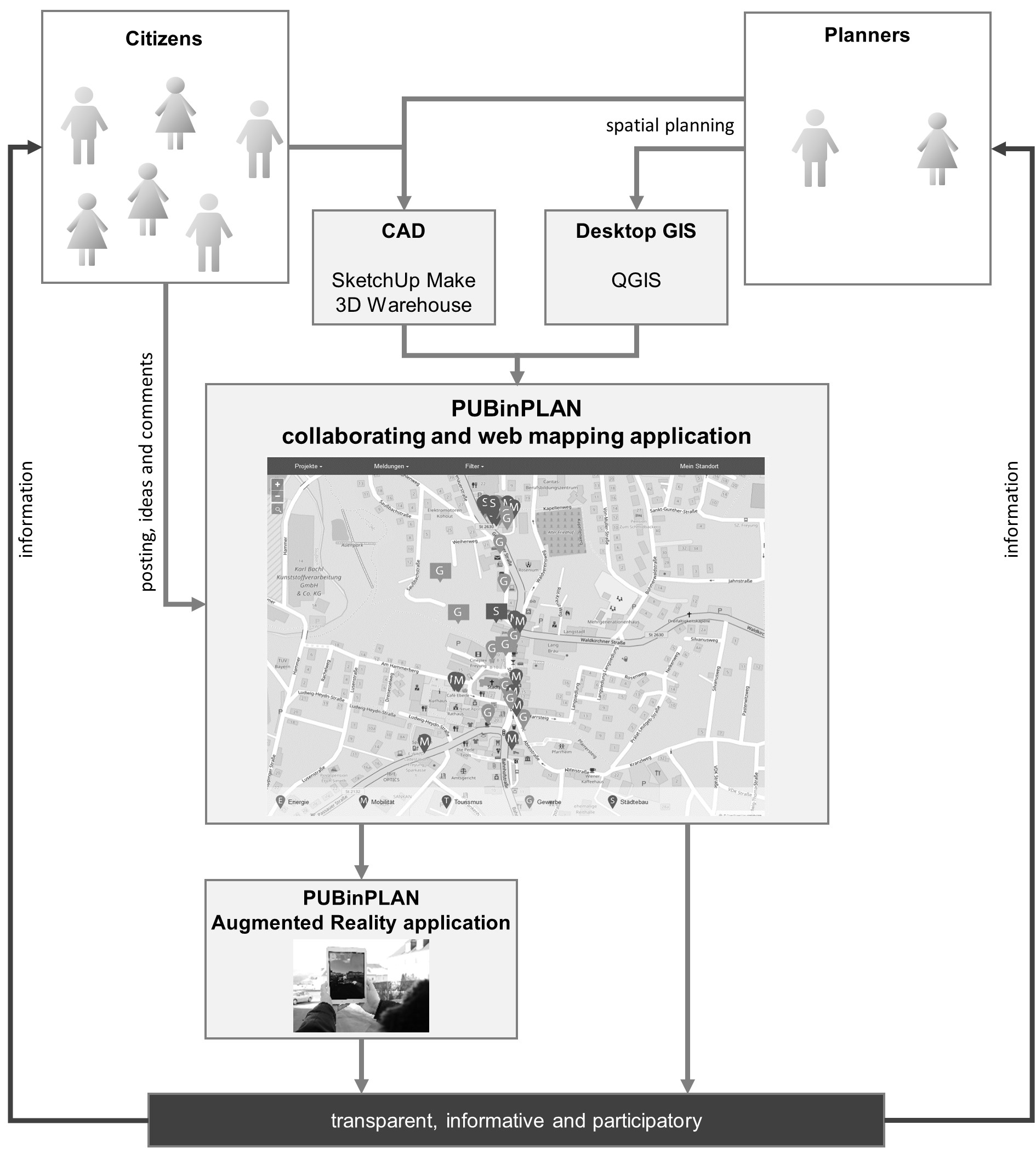
Figure 1: Concept and workflow of PUBinPLAN.
By integrating citizens‘ everyday experience through PUBinPLAN, the planning process can be qualified and the acceptance increased. Participants find transparent information about the project, its status and its progression and have the possibility to collaborate at all levels. By giving feedback to the visualized 3D models or comments, the project ideas are discussed at an early stage of the process. Figure 1 shows the concept and workflow of PUBinPLAN with the interaction and communication of citizens and planners and the visualization on a map and in AR. As a result, the platform not only provides transparent information, but also enables citizens to participate from the beginning and in an interactive manner. The developed GIS framework is described in the publication by Zink et al. [39].The development of the AR application is presented in the next chapter.
4. Augmented Reality in PUBinPLAN
4.1 Designing AR with Wikitude SDK and cross-platform Cordova
Displaying possible landscape and urban changes, AR can help citizens to understand the specific elaboration of individual measures and is therefore a central component in PUBinPLAN. Following Azuma [40], AR systems have three characteristics: (1) they combine real and virtual, (2) they are interactive in real time and (3) they are registered in 3D. In the context of PUBinPLAN and for the sake of using the AR app on mobile devices and being accessible by as many users and devices as possible, the development should be strictly independent of platforms and compliant with existing mobile standards. Therefore, we decided to develop a hybrid app using standard web technologies such as HTML5, CSS, JavaScript and build an app for the platforms iOS, Android, and Windows Phone with Cordova framework. Thus, the app can also be used in a standard browser via desktop computer.
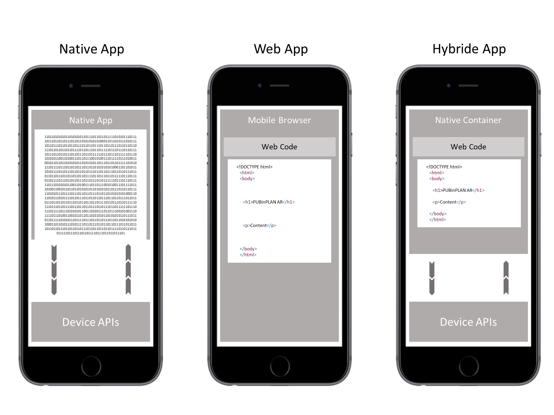
Figure 2 shows three different types of mobile applications: native, web and hybrid apps.
Native apps are written in the particular target platform’s native programming language like Java for Android or Objective C for iOS. This approach provides direct access to each system and device API and consequently to sensors, display, cameras as well as touch events and other inputs like a user pressing a button. In web apps, a webpage is displayed in the mobile devices’ browser. By using responsive design, it is possible to make it look (almost) like a native app, but due to system restrictions, pure web apps are not fully capable of accessing mobile devices’ hardware such as GPS, accelerometer, gyro on any device and even camera access on iOS devices. Hence a solution for developing a platform-independent app with nearly full access to hardware such as sensors and camera had to be found. In the third type displayed in figure 2, a cross-platform is used to build hybrid apps. With the cross-platform Cordova, you get a so called native container in which webpages are displayed. Cordova APIs provides access to the device’s hardware and system APIs.
Wikitude SDK was chosen after internal testing several AR frameworks including some free SDKs, toolkits and frameworks as well as paid ones. Most tested toolkits implemented marker-based tracking for 3D model positioning or augmentation in general. Vuforia8 has no native geolocation-based markerless Augmented Reality solution. ARToolKit9 was not maintained regularly, then it was still in beta status when obtained by DAQRI [41]. ARToolKit is available as an open source and is currently being maintained again. Metaio10 was considered as alternative, however, it got acquired by Apple in 2015 and is therefore no longer available on the free market [42].
Finally, Cordova was chosen. Cordova is an open source framework which allows to develop cross-platform applications using web technology such as HTML, CSS and JavaScript. The framework was originally developed as PhoneGap during the iPhoneDevCamp event in 2009. In 2011, Adobe acquired Nitobi (the original developer) and contributed the PhoneGap source code to the Apache Foundation. Apache Cordova was started as a new project. PhoneGap is an Apache Cordova distribution. Both PhoneGap and Cordova are used as synonyms nowadays [43].
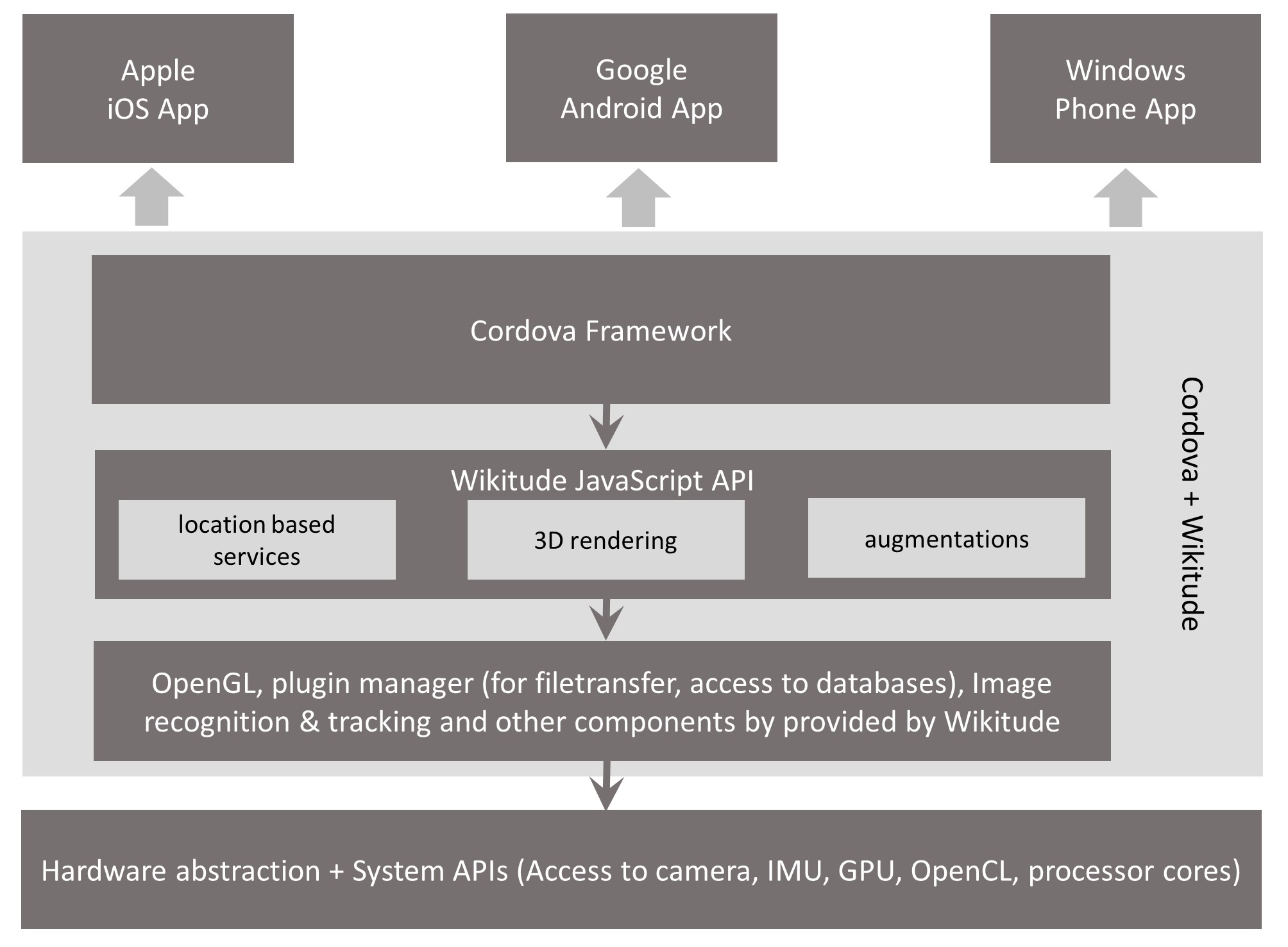
Figure 3: Wikitude SDK Architecture in Cordova framework.
As can be seen in figure 3, Wikitude and Cordova offer the possibility to gain access to the system’s and the device’s hardware without specifically and exactly knowing each single piece of hardware. Using hardware abstraction makes sense, because it is not necessary to implement a new app for a specific device. Both hardware abstraction layer and C++ layer with a native implementation of OpenGL for Android and iOS way, as well as app and system-specific plugins offer the usage of different standardized processes such as file transfer and database which are both absolutely necessary for loading and displaying one or more 3D models in an efficient way out of a database. On top, there are layers for using plain and simple JavaScript, HTML5, CSS code to write the app. Cordova provides interfaces to the system’s (iOS, Android, Windows Phone) native APIs.
4.2 Development
During the pre-development planning phase, the following requirements came up for an AR application so as to generate an added value for PUBinPLAN. First, the app should be developed as platform-independent in order to address as many users as possible. Thus, it should at least be runnable and usable on iOS and Android devices and rely on current web technologies like HTML5, CSS3, JavaScript, Databases and a REST backend. Second, the application should not use any markers or features for positioning the augmentations on the mobile devices’ displays. Therefore, the mobile devices’ sensors GPS, IMU and cameras have to be integrated. Third, a connection to the PUBinPLAN database is necessary for displaying the information and models which were collected in the crowdsourcing tool.
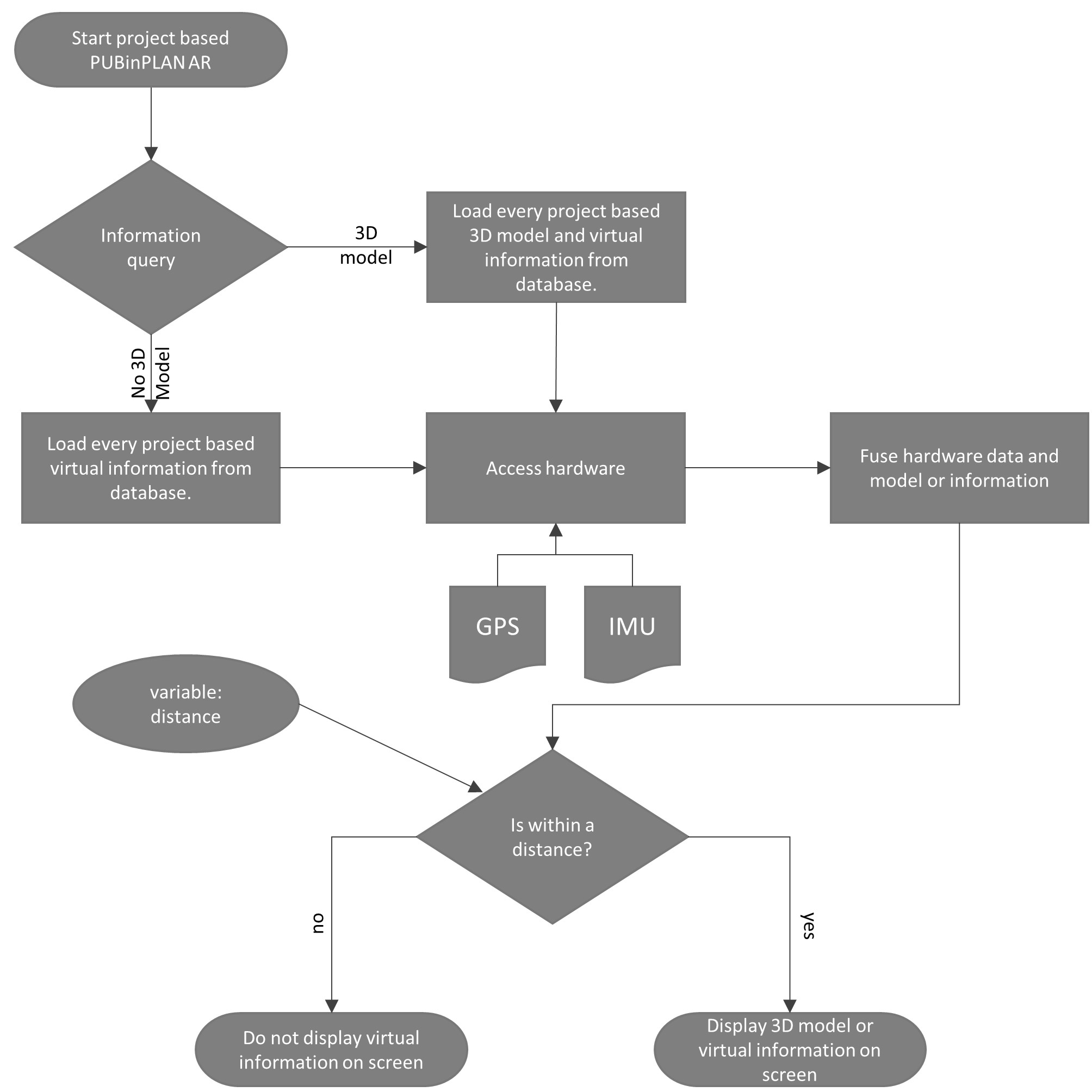
Figure 4: PUBinPLAN AR flow chart.
Figure 4 shows the flow chart of the PUBinPLAN AR application being started on a mobile device. Every computation on 3D models or positioning of points of interest is done on the device. When PUBinPLAN Augmented Reality application is launched from the PUBinPLAN website by clicking a given information in a project, the first thing done is to check if there’s one or more 3D models existing in the provided project-based JSON document. If this is the case, every project-based model and its pertinent information is loaded from the PUBinPLAN database. Due to the increasing capabilities of smart devices every 3D model is computed on the device itself. If there is no model given, project-based information is loaded from the database to provide so-called points of interest (see figure 4) as augmented information on screen. The second step is to get access to hardware such as camera, GNSS (global navigation satellite system) sensors, accelerometer, gyroscope and compass and use this data for computing an exact position and positioning of the mobile device.
5. First results from the AR implementation
PUBinPLAN is currently tested in rural and urban development projects: a project for site planning for solar heating in municipality scale, in a primary school and a university project. The focus is on the usability of the crowdsourcing tool and its implementation in planning and participation processes. At the same time, the comments and postings of the crowdsourcing were used for testing the AR application. Comments or points of interest (POI) are shown when there’s no model given for the current message in the PUBinPLAN project, as you can see in the screenshot in figure 5. For better orientation, a radar with all comments in the vicinity of the current location is additionally displayed. The screenshot shows the visualization as it is done by Wikitude. By using the touch-optimized web framework jQuery mobile [44], more possibilities for designing the comments are given. This will be developed in a next step.
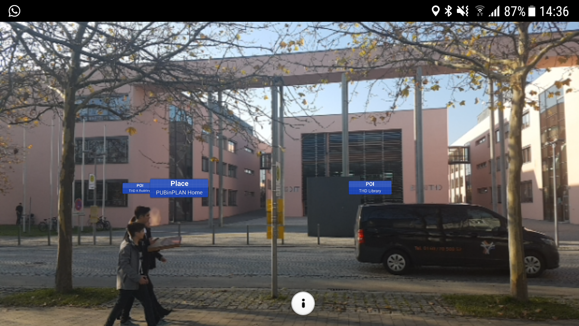
Figure 5: Comments and POIs in AR.
As described in chapter 3, PUBinPLAN offers the functionality to add 3D models to the crowdsourcing WebGIS and visualize them via AR. The screenshot (see fig. 6) shows the monitor of a smartphone (Samsung Galaxy S7 Edge, Android 7 Nougat) where a bench is displayed in AR. The 3D model of the bench comes from the Trimble SketchUP 3D Warehouse database (dumor, October 12th, 2017). Although AR can visualize the landscape change, there is still a need for development. In the example (figure 6), the bench is correctly positioned in the lawn, but the bench’s scale appears too large. This results from an inaccurate distance estimation between smartphone and 3D model. The use of GPS at a building’s window might be responsible for this. Currently, the orientation of the model given by the parameters heading, roll and tilt is fixed. In a next step, the user him/herself should be able to specify this information. To this end, the map from the crowdsourcing application is used. The models can thus be purposefully integrated into the landscape or environment and visualized via AR.
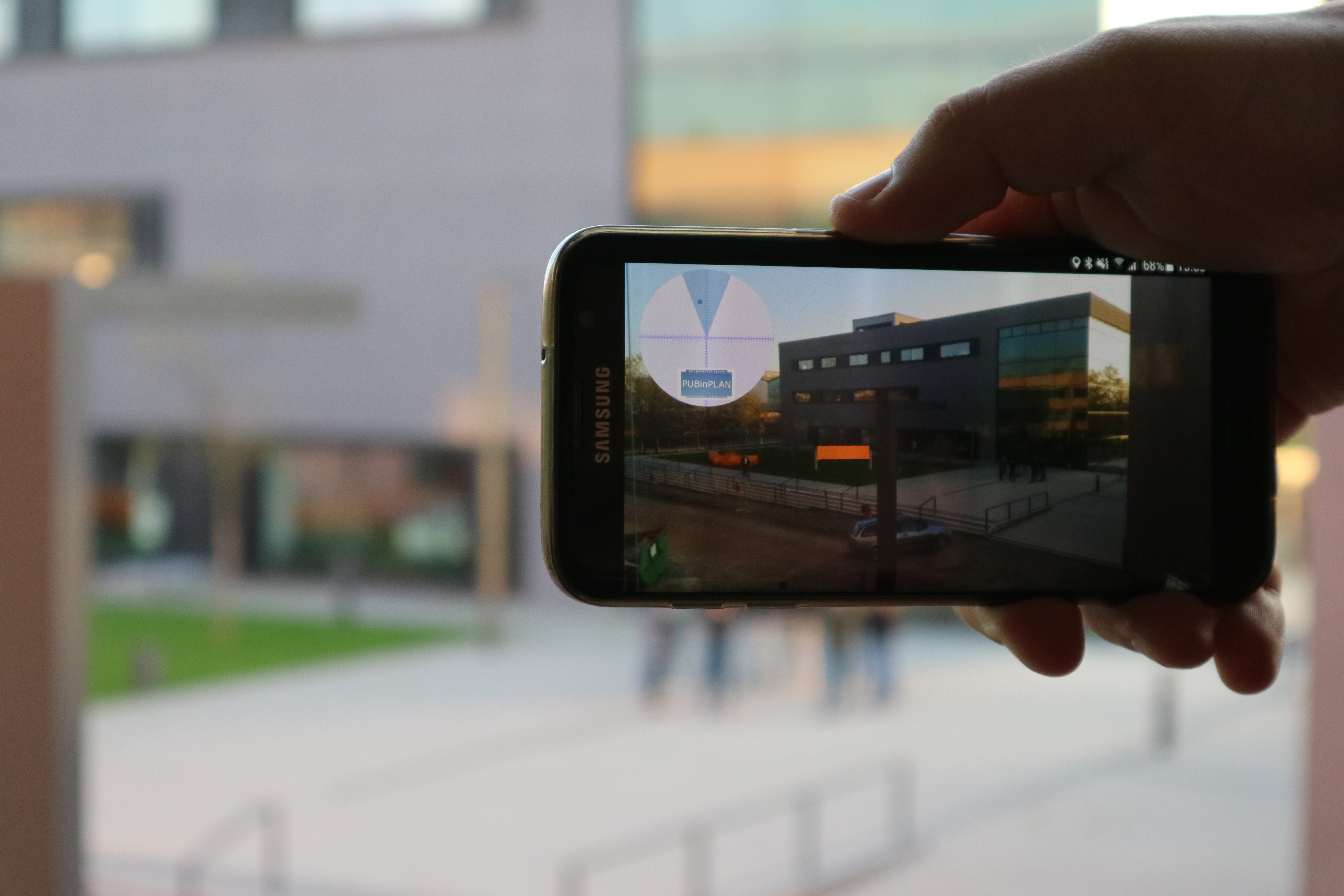
Figure 6: Bench in AR.
6. Conclusion
Using AR as an additional information and communication tool for citizens to participate in municipality and spatial planning processes has both advantages and drawbacks. On the one hand, powerful smartphones with high-quality cameras and displays have become standard. This makes access to the AR technology
possible for many people. Citizens may get informed in an innovative way, thus reaching the first step of Arnstein´s ladder of citizen participation [45]. Furthermore, internet and Web 2.0 offer the opportunity to bring citizens together and make the information consumer also an information producer (prosumer). Because of the change in interpersonal communication and the digitization of planning processes, interactive communication, called many-to-many, is becoming increasingly important. Innovative participation has to take up the possibilities of digital transformation, as citizens, according to Portmann et al. ([15], p. 1), will be given the opportunity to play an active part in shaping their environment, which is in accordance with the requirements of the community. AR can therefore also serve as a motivation for citizens to search information about local issues and to participate in local planning and decision-making processes.
On the other hand, these technologies often over-challenge individuals (especially older people) and, in the case of technical problems, they might even lead to frustration. In order to avoid frustration, user-friendliness, a clear user interface and moderating planning processes can help. Digital forms of participation should not be understood as a mere game, but as an additional offer for both citizens and stakeholders to contribute to sustainable and accepted planning processes. It is therefore necessary to analyze the effectiveness of different forms of participation [46], which especially applies to digital participation by crowdsourcing and augmented reality. This is not about the abolition of existing participation solutions, but the integration of digital possibilities into participation processes. In current and future projects and beyond, the further development of the platform PUBinPLAN has to be evaluated with regard to its impact and the outcome of participation on planning and with regard to the goals to simplify, improve and enrich participation in public planning processes.
7. Acknowledgments
The project PUBinPLAN, public in spatial planning supported by information and communication technology, is founded by the program FHProfUnt from the Federal Ministry of Education and Research (BMBF, FKZ 03FH027PX4). Leading Partner is Deggendorf Institute of Technology. The Universities of Passau (Geography) and Bayreuth (Urban and regional development) are scientific partners. Further partners are KlimaKom eG, hausfreunde – Architekten GbR, Landschaft+Plan and the Agency for Rural Development in Lower Bavaria.
8. References
[1] Krüger, Sebastian (2012): Stuttgart 21 – Interessen, Hintergründe, Widersprüche. In: Informationen zur Raumentwicklung (11), p. 589–604.
[2] Beitzer, Hannah (2015): Den Bürger umarmen. In: Süddeutsche Zeitung, 03.06.2015. Available online at http://www.sueddeutsche.de/sport/hamburger-olympiabewerbung-den-buerger-umarmen-1.2503923.
[3] Schürmann, Benjamin (2016): Die Struktur politischer Online-Partizipation - Eine empirische Analyse der Nutzer von openPetition. In: Laura Leißner, Halina Bause und Lennart Hagemeyer (Eds.): Politische Kommunikation - neue Phänomene, neue Perspektiven, neue Methoden. 1st Edition. Berlin: Frank & Timme Verlag für wissenschaftliche Literatur (Düsseldorfer Forum Politische Kommunikation (DFPK), 6).
[4] Rinne, Ulf; Zimmermann, Klaus F. (2016): Die digitale Arbeitswelt von heute und morgen. In: Aus Politik und Zeitgeschichte (APuZ) 66 (18-19), p. 3–9.
[5] Tsai, Bor-Wen; Lu, Dau-Jye; Chung, Ming-Kuang; Lien, Mei-Chih (2013): Evaluation of PPGIS empowerment — A case study of Meinong Yellow Butterfly Valley in Taiwan. In: Journal of Environmental Management 116 (February), p. 204–212.
[6] Harris, Trevor M.; Weiner, Daniel (2002): Implementing a community-integrated GIS: perspectives from South African fieldwork. In: William J. Craig, Trevor M. Harris und Daniel Weiner (Hg.): Community participation and geographic information systems. New York: Taylor & Francis, p. 246–258.
[7] Sieber, Renee (2006): Public Participation Geographic Information System: A Literature Review and Framework. In: Annals of the American Geographers 96 (3), p. 491–507.
[8] Goodchild, Michael F. (2010): Twenty years of progress. GIScience in 2010. In: Journal of Spatial Information Science (JOSIS) (1), p. 3–20.
[9] Sui, Daniel Z.; Elwood, Sarah; Goodchild, Michael F. (2013): Crowdsourcing geographic knowledge. Volunteered geographic information (VGI) in theory and practice. Dordrecht, New York: Springer.
[10] Kanwischer, Detlef (2014): Digitale Geomedien und Gesellschaft. Zum veränderten Status geographischen Wissens in der Bildung. In: Geographische Rundschau (6), p. 12–17.
[11] O‘Reilly, Tim (2009): What is Web 2.0. Design patterns and business models for the next generation of software. Sebastopol, CA, USA: O‘Reilly Media, Inc.
[12] Hanrath, Jan; Leggewie, Claus (2013): Revolution 2.0? Die Bedeutung digitaler Medien für politische Mobilisierung und Protest. In: Stiftung Entwicklung und Frieden Institut für Entwicklung und Frieden, Tobias Debiel, Jochen Hippler, Michèle Roth und Cornelia Ulbert (Hg.). Bonn (Schriftenreihe der Bundeszentrale für Politische Bildung, 1366), p. 157–172.
[13] Finger, Matthias; Razaghi, Mohamad (2017): Conceptualizing „Smart Cities“. In: Informatik Spektrum 40 (1), p. 6–13.
[14] Günther, Stephan; Jakubowski, Peter; Schweitzer, Eva (2017): Ansatzpunkte für die digitale Transformation der Städte in Deutschland. In: Geographische Rundschau (7-8), p. 44–51.
[15] Portman, Edy; Finger, Matthias; Engesser, Hermann (2017): Smart Cities. In: Informatik Spektrum 40 (1), p. 1–5.
[16] Westholm, Hilmar (2012): e-Democracy. In: Astrid Ley und Ludwig Weitz (Eds.): Praxis Bürgerbeteiligung. Ein Methodenhandbuch. 4th Edition Bonn: Verlag Stiftung Mitarbeit (Arbeitshilfen für Selbsthilfe- und Bürgerinitiativen, 30).
[17] Broschart, Daniel; Zeile, Peter; Streich, Bernd (2013): Augmented Reality as a Communication Tool in Urban Design Processes. In: Manfred Schrenk (Ed.): Planning times. You better keep planning or you get in deep water, for the cities they are a-changin‘. Proceedings of the 18th International Conference on Urban Planning, Regional Development in the Information Society (20-23 May 2013; Rome, Italy) [REAL CORP 2013 Planning times]. Schwechat-Rannersdorf: Eigenverlag des Vereins CORP - Competence Center of Urban and Regional Planning, p. 119–126.
[18] Helbig, Dirk; Pietsch, Matthias; Schütz, Lars; Bade, Korinna; Richter, Andreas; Nürnberger, Andreas (2016): Online-Beteiligung in Entscheidungs- und Planungsprozessen - Anforderungen aus der Praxis. In: AGIT - Journal für Angewandte Geoinformatik (2), p. 508–517.
[19] Küpper, Patrick; Levin-Keitel, Meike; Maus, Friederike; Müller, Peter; Reimann, Sara; Sondermann, Martin et al. (Eds.) (2014): Raumentwicklung 3.0 - Gemeinsam die Zukunft der räumlichen Planung gestalten. 15. Junges Forum der ARL (June 6-8, 2012 in Hanover, Germany). 1st Edition. Hannover: Akademie für Raumforschung und Landesplanung (Arbeitsberichte der ARL, 8).
[20] Open Knowledge Foundation Deutschland e.V. (Ed.): Frankfurt gestalten. Available online at http://www.frankfurt-gestalten.de.
[21] Stadt Friedrichshafen (2016): Sag‘s doch. Available online at https://sags-doch.de/#pageid=1, last verified on Jan 20th, 2016.
[22] Where Group GmbH & Co. KG (2016): Meldemax. Available online at https://meldemax.com/, last verified on Jan 20th, 2016.
[23] Caudell, Thomas P.; Mizell, David W. (1992): Augmented Reality: An application of heads-up display technology to manual manufacturing processes. In: Proceedings of the Twenty-Fifth Hawaii International Conference on System Sciences (7-10 Jan 1992; Kauai, HI, USA). Los Alamitos, CA, USA: IEEE Computer Society Press, p. 659–669.
[24] Kato, Hirokazu; Billinghurst, Mark (1999): Marker tracking and HMD calibration for a video-based augmented reality conferencing system. In: Proceedings of the 2nd IEEE and ACM International Workshop on Augmented Reality 1999 (IWAR ‚`99), p. 85–94.
[25] Carmigniani, Julie; Furht, Borko; Anisetti, Marco; Ceravolo, Paolo; Damiani, Ernesto; Irkovic, Misa (2011): Augmented reality technologies, systems and applications. In: Multimedia Tools and Applications 51 (1), p. 341–377.
[26] Graham, Mark; Zook, Matthew; Boulton, Andrew (2013): Augmented reality in urban places: contested content and the duplicity of code. In: Transactions of the Institute of British Geographers 38 (3), p. 464–479.
[27] Kan, Tai-Wei; Teng, Chin-Hung; Chen, Mike Y. (2011): QR Code Based Augmented Reality Applications. In: Borko Furht (Hg.): Handbook of Augmented Reality. 1. Aufl. New York, NY: Springer Science+Business Media, LLC, p. 339–354.
[28] Cirulis, Arnis; Brigmanis, Kristaps Brigis (2013): 3D Outdoor Augmented Reality for Architecture and Urban Planning. In: Procedia Computer Science 25, p. 71–79.
[29] Broll, Wolfgang (2013): Augmentierte Realität. In: Ralf Dörner, Wolfgang Broll, Paul Grimm und Bernhard Jung (Hg.): Virtual und Augmented Reality (VR/AR). Grundlagen und Methoden der Virtuellen und Augmentierten Realität. Berlin, Heidelberg: Springer (eXamen.press), p. 241–294.
[30] Morkos, Beshoy; Taiber, Joachim; Summers, Joshua; Mears, Laine; Fadel, Georges; Rilka, Torsten (2012): Mobile devices within manufacturing environments. A BMW applicability study. In: International Journal on Interactive Design and Manufacturing (IJIDeM) 6 (2), p. 101–111.
[31] Stocker, Alexander; Spitzer, Michael, Kaiser, Christian; Rosenberger, Manfred; Fellmann, Michael (2017): Datenbrillengestützte Checklisten in der Fahrzeugmontage. In: Informatik Spektrum 40 (3), p. 255–263.
[32] Broschart, Daniel; Höhl, Wolfgang (2015): Augmented Reality in Architektur und Stadtplanung. In: GIS Science 1, p. 20–29.
[33] Bilge, Gulsah; Hehl-Lange, Sigrid; Lange, Eckart (2016): The use of mobile devices in participatory decision-making. In: JoDLA - Journal of Digital Landscape Architecture, p. 234–242.
[34] Bähler, Lukas; Stark, Hans-Jörg (2012): Augmented Reality auf Smartphones in der Bauplanung. In: Josef Stobl, Thomas Blaschke und Gerald Griesebner (Hg.): Angewandte Geoinformatik 2012. Beiträge zum 24. AGIT-Symposium Salzburg. Symposium für Angewandte Geoinformatik (Salzburg; 04.-06.06.2012). Berlin: Wichmann.
[35] Reinwald, Florian; Berger, Martin; Stoik, Christop; Platzer, Mario; Damyanovic, Doris (2014): Augmented Reality at the Service of Participatory Urban Planning and Community Informatics-a case study from Vienna. In: The Journal of Community Informatics 10 (3). Available online at http://ci-journal.net/index.php/ciej/article/view/1087/1107.
[36] Rockmann, Lisa; Adler, Simon (2015): Augmented-Reality als Erweiterungs-Tool des partizipativen Austausches in Planungsprozessen zum Ziel einer integrativen städtebaulichen Entwicklung. In: Manfred Schrenk, Vasily V. Popovic, Peter Zeile, Pietro Elisei und Clemens Beyer (Eds.): Plan together. Right now. Overall. Proceedings of the 20th International Conference on Urban Planning, Regional Development and Information Society (REAL CORP) 2015 (May 5-7, 2015; Ghent, Belgium). Wien: Eigenverlag des Vereins CORP - Competence Center of Urban and Regional Planning, p. 83–92.
[37] Küspert, Stefan; Zink, Roland (2017): Concept of a Digital Communication Platform to Increase the Citizens’ Interest in Spatial Planning. In: Journal of Digital Landscape Architecture (JoDLA) (2), p. 136–143.
[38] Gosch, Phil (2016): 3D Modelloptimierung für mobile Endgeräte. Hg. v. Codefluegel GmbH. Available online at https://codefluegel.com/de/3d-modelloptimierung-fuer-mobile-endgeraete/, last verified on Oct 4th, 2017.
[39] Zink, Roland; Küspert, Stefan; Haselberger, Johannes; Marquardt, Anna; Schröck, Sebastian (2016): Interaktives GIS-Framework für partizipative Raumplanungsverfahren. In: AGIT - Journal für Angewandte Geoinformatik (2), p. 488–497.
[40] Azuma, Ronald T. (1997): A Survey of Augmented Reality. In: Presence: Teleoperators and Virtual Environments 6 (4), p. 355–385.
[41] Kim, Michelle (2015): DAQRI Acquires Augmented Reality Software Pioneer ARToolworks, Makers of Open Source Augmented Reality Platform. ARToolKit. DAQRI to Offer ARToolKit Free and Open Source to the AR Community. Hg. v. Business Wire Inc. und Brew Media Relations. Available online at http://www.businesswire.com/news/home/20150513006304/en/DAQRI-Acquires-Augmented-Reality-Software-Pioneer-ARToolworks, last verified on Oct 3rd, 2017.
[42] Miller, Ron; Constine, Josh: Apple Acquires Augmented Reality Company Metaio. Hg. v. Oath Inc. Available online at https://techcrunch.com/2015/05/28/apple-metaio/.
[43] Steyer, Ralph (2017): Cordova. Entwicklung plattformneutraler Apps. Wiesbaden: Springer Vieweg.
[44] jQuery Foundation (2017): jQuery mobile. A Touch-Optimized Web Framework. Unter Mitarbeit von A. Schmitz, A. Colom, G. Schulhof, G. Sguin und J. de Groot. Available online at https://jquerymobile.com, last verified on Oct 6th, 2017.
[45] Arnstein, Sherry R. (1969): A Ladder Of Citizen Participation. In: Journal of the American Institute of Planners 35 (4), p. 216–224.
[46] Selle, Klaus (2013): Über Bürgerbeteiligung hinaus: Stadtentwicklung als Gemeinschaftsaufgabe? Analysen und Konzepte. Detmold: Rohn (Edition Stadt-Entwicklung). Available online at http://www.pt.rwth-aachen.de/inprogress.

Prof. Dr. Roland Zink
Roland Zink received his doctorate at the University Passau on the subject of the transition of the energy sector and the designing of a sustainable energy supply under a spatial perspective. Since 2013 he is Professor for spatial sciences and information technology at Deggendorf Institute of Technology and scientific head of the Research Group “Applied Energy Research” at the Technology Campus Freyung and also spokesman of the Research Group “Energy Systems and Technologies”. In addition to further development of spatio-temporal energy models, his current research focuses on innovative opportunities for participation of stakeholders in spatial planning processes through new media.
Roland Zink promovierte an der Universität Passau zum Thema der Transformation des Energiesektors und der Gestaltung nachhaltiger Energieversorgungsstrukturen aus einer räumlichen Perspektive. Seit 2013 ist er Professor für Raumwissenschaften und Informationssysteme an der Technischen Hochschule Deggendorf und wissenschaftlicher Leiter der Forschungsgruppe „Angewandte Energieforschung“ am Technologie Campus Freyung sowie Sprecher der Forschungsgruppe „Energiesysteme und Technologien“. Neben der weiteren Entwicklung raum-zeitlicher Energiemodelle, konzentriert sich seine aktueller Forschungstätigkeit auf innovative Partizipationsmöglichkeiten von Akteuren in räumlichen Planungsprozessen durch neue Medien.
Kontakt / Contact:

Martin Steininger B.A.
Martin Steininger holds a Bachelor’s degree in Internet Computing from Passau University. After having worked some time in Hamburg he returned to Bavaria and is currently focusing on mobile and spatial systems, autonomous vehicle technology and geoinformatics as part of the degree programme Applied Computer Science at DIT. He is a member of the Applied Energy Research Group at the technology campus in Freyung where he also helps elaborating concepts and solutions through new media and AR within the framework of a participation platform for spatial planning processes.
Martin Steininger machte an der Universität Passau den BA Internet Computing. Nach einem Zwischenstopp in Hamburg fokussiert er sich im Studiengang Angewandte Informatik an der THD auf mobile und räumliche Systeme, autonome Fahrzeugtechnik und Geoinformatik. Am Technologie Campus in Freyung ist er in der Forschungsgruppe „Angewandte Energieforschung“ tätig und erarbeitet im Rahmen einer Partizipationsplattform für räumliche Planungsprozesse durch den Einsatz neuer Medien Konzepte und Lösungen im Bereich der Augmented Reality.
Kontakt / Contact: